Previous
Saturday July 31, 2010
Rafting the Merced
|
Saturday
September 4, 2010
North Dome
|
Next
Sunday September 5, 2010
Glacier Point
|
Labor Day Weekend in Yosemite, and
traffic was predictably awful. It took us over 6 hours total to
get to Yosemite on Friday night, arriving after 9:30pm. We were
already exhausted, and still had to set up tents, air mattresses,
sleeping bags, and put everything away in the bear box. Our
campsite was right next to the bathroom, - the map shows the bathroom
is 2 spots away; not true at all. This site was also not very
flat - we were picking spots for tents and trying to avoid tripping
over rocks in the dark - not too fun. It was after 11 before I
was ready for bed, and there was a college aged girl in the camp next
to ours that simply would not shut up. Before going to bed I
finally decided to ask them nicely to quiet down and they complied.
The next morning it took be quite a while to get organized and I didn't
leave camp until 7:30. I saw almost no one on the trail to Mirror
Lake - I saw one woman jogging back down the trail. Eventually a
saw a morning hiker coming back down the trail as well.... how could I
tell he was a morning hiker? He had a sweater on that was clearly
unnecessary, and was using a comically huge impractical walking stick
that was also clearly unnecessary.
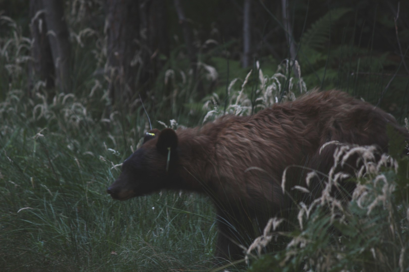
While I was continuing on the Mirror Lake loop toward Snow Creek, I saw
a black bear on the trail directly ahead of me. He noticed me at
the same time I noticed him. Unfortunately my camera was in my
buttpack. I turn the buttback around slowly, got the camera out,
all the time the bear was watching me. I wasn't at all afraid of
the bear, but I wanted pictures. By the time I started switching
lenses - a good 30-45 seconds after the bear saw me - he was in the
trees. By the time I was ready to take his picture - nearly a
minute after he saw me - he was too deep in the trees to pursue.
I started kicking myself for not having the camera ready and blowing a
perfect photo op.
Less than 3 minutes after loosing the bear in the trees, I saw another
bear coming down the path in front of me. This time I was ready,
and I opened fire quickly, taking a couple dozen pictures and plenty of
video. This bear was less skittish than the first bear, and made
his way around me in the woods only about 50' from the trail, and then
returned to the trail in back of me, continuing his journey towards the
campgrounds and breakfast.
I few minutes later I reached the base of Snow Creek trail, and saw a
jogger headed down Snow Creek and back toward camp. I warned him
that there were two bears on the trail ahead of him. In a German
accent he expressed concern, but I told him he'd be fine as long as he
didn't startle them. Germany has long since killed all their
bears, and recently killed the first bear sighted in Germany in over
100 years.
http://en.wikipedia.org/wiki/Bear_JJ1
I took a few pictures of the mileage markers and started up the
switchbacks of Snow Creek trail. 8:40am, 2.4 miles from the
stables.
Soon I found myself surrounded
by bugs that were apparently eager for the salt in my sweat.
After 10 minutes or so the shade was gone and I was in full sun without
bugs. The bugs were really annoying but I wasn't sure full sun
was a necessary trade off. The trail continues up
mercilessly. I had decided to go up this trail and down Yosemite
Falls trail for several reasons:
a) Yosemite Falls is supposed to be brutal granite stairs, and I hate
brutal granite stairs
b) I could ride a bus back to the campground from Yosemite Falls, but
buses were not running yet, and also did not take me to the base of
Snow Creek
c) Yosemite Falls itself is in shade in the morning, making picture
taking less than ideal
d) I'd been up Snow Creek trail before and knew I could do it - the
trail is steep, but there are no stairs to speak of. In May 1996
I tried to do this loop once before, only to be turned around by snow
in the high country - I couldn't follow the trail, and getting lost
seemed like a poor idea. I'd also seen a rattlesnake on one of
the switchbacks of the trail in 1996, so I was especially alert this
morning.
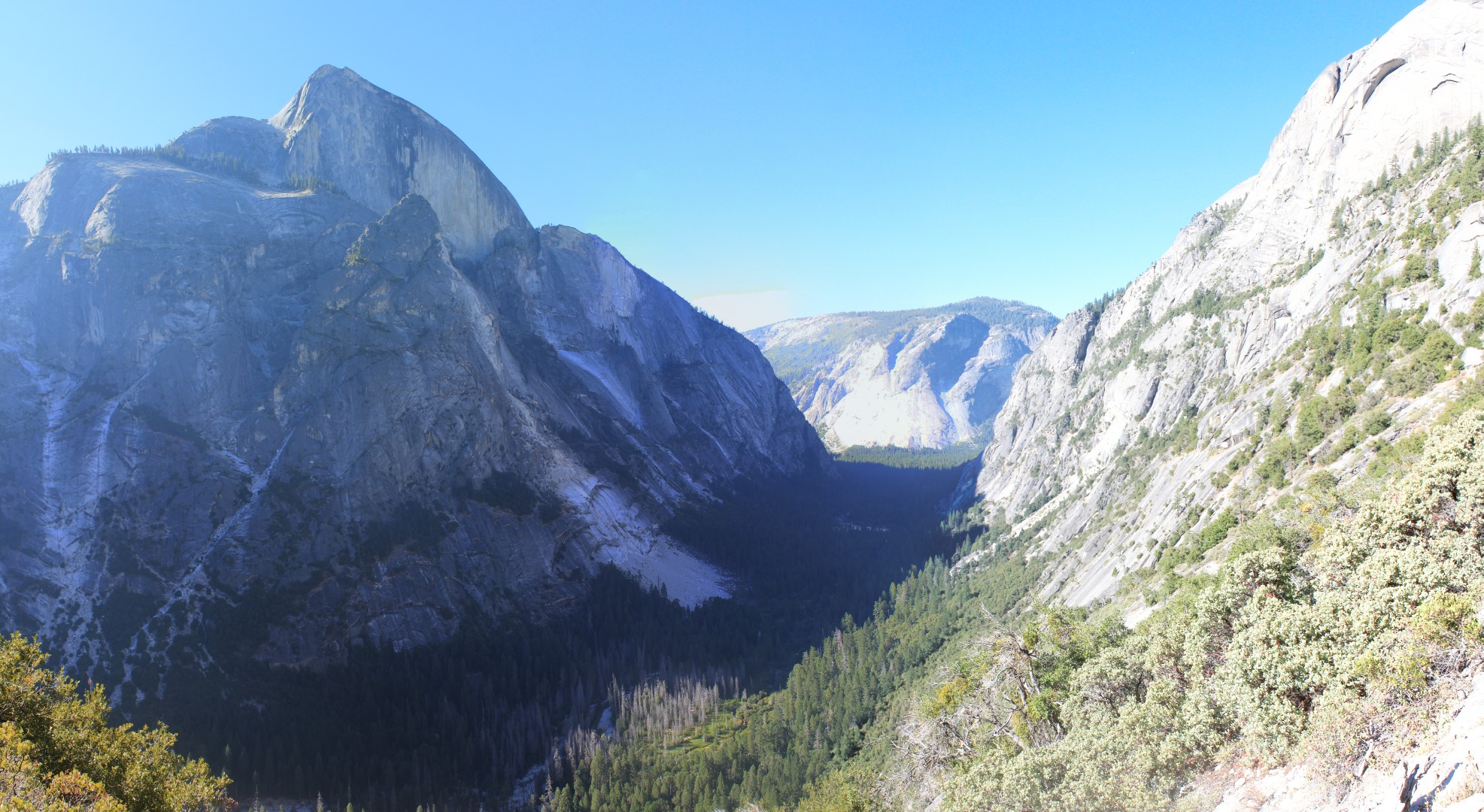
Panoramic
picture
The
March 28, 2009 Awhiyah Point slide is visible in the center.
Just left of the top Half Dome, you can see the very steep granite
approach to the Half Dome cables.
The approach features steps cut into the granite and was repaired over
the last few years by trail crews, closing the trail during weekdays.
I took a couple of breaks in the shade on the way up. I made
better progress than I expected, judging my progress against the walls
across the canyon. Mirror Lake and Half Dome were in the shade
all morning so the pictures were none too impressive.
As I tried to take a picture toward the top of the trail, the camera
refused to work. I had the book with me so I spent a quite a
while troubleshooting to no avail. I was not pleased that my
<90 day old not-too-cheap camera had bit the dust, and now my only
camera was the worthless camera on my Blackberry. I remembered
that I had packed an extra 8G memory card, and decided that I would beg
anyone I could to use their camera when I got to North Dome to try to
salvage some pictures out of this mess.
Snow Creek doesn't really top out like many canyon trails do - the
climbing becomes easier and more gradual, but there's no definite rim
that says 'you're here'.
I finally encounted another hiker - I younger guy with a full pack was
coming down the trail. He had separated from his party of 3
others cause he was feeling sick and wanted to get out of the
backcountry. The rest of his party was going to be on Cloud's
Rest this morning, where his sister's boyfriend was likely to propose
to his sister.
I got the intersection near the bridge over Snow Creek. It is
nothing exciting, and I think I'd gotten this far before. The
forest is not at all dense up top, leaving plenty of sunlight coming
down on anyone crazy enough to hike here. The trail continues up,
gradually climbing the Snow Creek drainage. Now it was getting
late - around 11am, and I realized that I was nowhere near getting to
North Dome. Now I realized I was making worse time than I
expected, and I had alot of hiking to do.
The trail makes a switchback when it runs into a tributary of Snow
Creek, then returns back for another visit after climbing uphill for
another 5 minutes or so. There I saw a group of 6 college aged
hikers with full packs on refilling their water bottles with a filter
in the creek at the waterfalls. They were all busy talking
amongst themselves - only their guide would talk to me. He was
perhaps my age, and told me he guides parties into the backcountry
regularly. This group had apparently done this hike as kids and
were having a reunion of sorts. After a few minutes I asked one
of them of he would refill one of my water bottles, since they had a
filter - he seemed a little put out but complied. I started with
about 6 liters of water, which is more than I've ever used on a hike,
but it was hot and it seemed stupid to pass a perfectly good
opportunely to top off without doing so. I pulled out my low-res
topo maps that I'd printed for free online and decided I was finally
near the intersection of the trail that goes back out to North Dome.
The trail continued uphill - I had now been hiking uphill for over 4
hours. Finally I reached the intersection at noon. I was
surprised to see the sign indicate we were only 1.5 miles from Tioga
Pass road - coming in from the road would be cheating! I stopped
for lunch. I don't bring much real food on these hikes - a couple
small bags of chips, a couple of apples, a sandwich, and plenty of
sugary candy to keep me going. I was really running late now - it
was already noon, and I was still 2.5 miles from the North Dome
turnoff. Then
I had to get out to North Dome - another half mile each way on a class
1 scramble, which I was expecting to be steep and scary. Later I
still had to hike a few miles over to Yosemite Falls before coming down
the Yosemite Falls trail.
The trail toward North Dome soon started up again. I was tired of
hiking up, but it wasn't too steep or entirely unexpected. I saw
plenty of dayhikers coming back from North Dome - they had all come
from Tioga Pass road. Almost all of them were woefully unprepared
for this hike - most of them were clearly out of water. I saw a
family of 5 carrying a total of 5 quart bottles, all of them nearly
empty. I passed by the turnoff to Balancing Rock - I'd decided it
wasn't worth the legwork to see and I was off schedule anyhow.
I was fairly confused when I started seeing a relatively unobstructed
view of Half Dome and could not see North Dome. Then the trail
started downhill, and I still couldn't see North Dome. I
remembered from the topo maps that the trail went down before North
Dome, but not even being able to find North Dome from here at least
meant I wasn't likely to have to climb very far up it to get to the
top. The trail continued downhill for another 15 minutes or so
before the intersection to the half mile North Dome
trail.
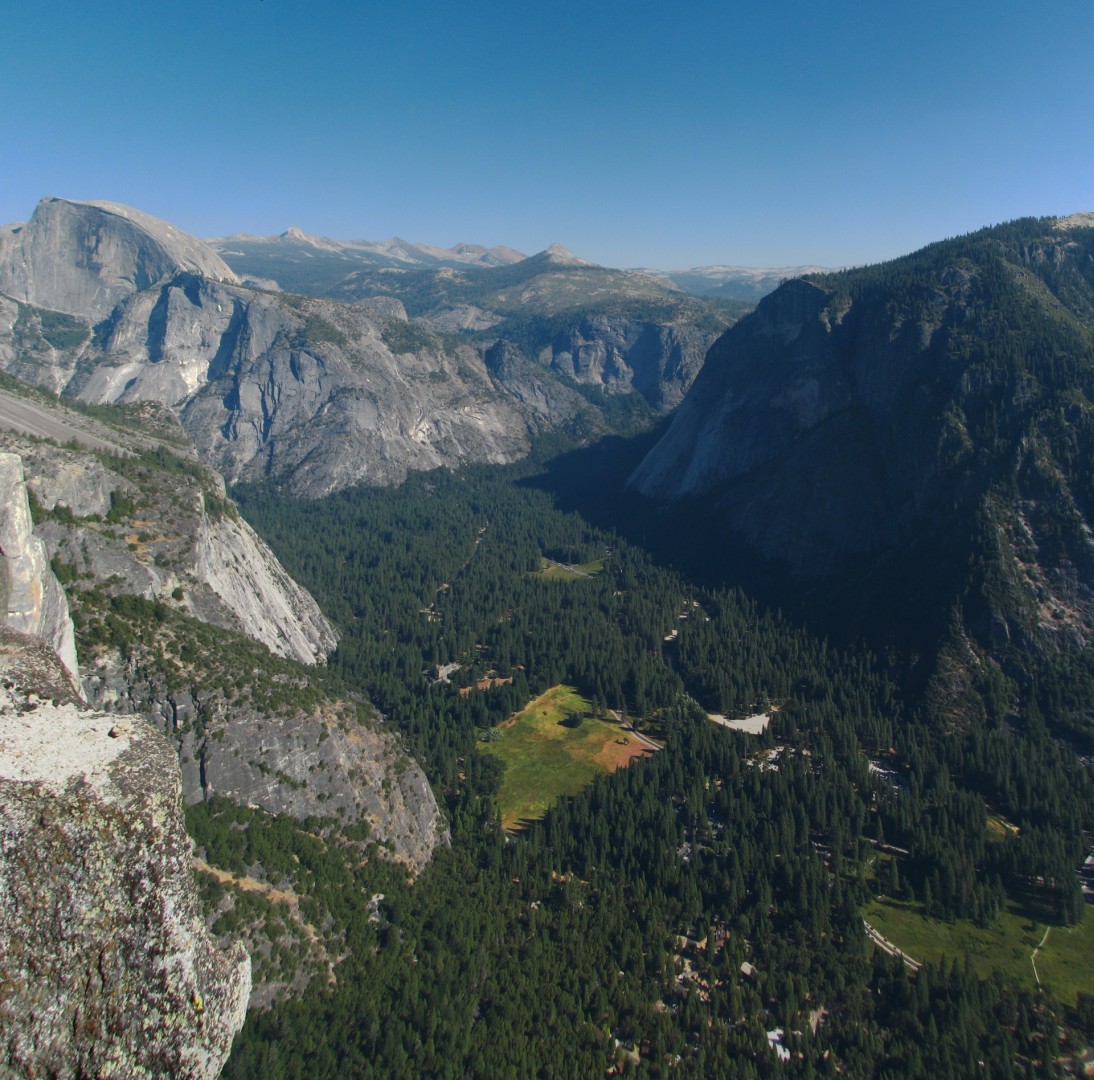
Click here for a panoramic picture of
Cloud's Rest, Half Dome, and North Dome
It was now after 1pm. More
downhill. Fortunately the 'class 1 scramble' aspect of this hike
was vastly overstated. I got down to the start of the Dome itself
and found an older couple with full packs in the trees who were
searching for the best place to pitch a tent. I got up my nerve,
wandered over toward them, explained how my camera had died, and begged
them to let me borrow a camera. My memory card was too new to
work in the woman's older point and shoot Nikon, but it worked in the
guy's Canon A720 8 meg point and shoot. I wandered out onto the
Dome and took pictures for about 10 minutes at most. The battery
indicator came on immediately, and I had no idea whether this guy had
spare batteries, so I was much more conservative in my picture taking
than I would have been otherwise - I took perhaps 20 shots total.
When I wandered back and found the couple I told them I noticed his
battery was low and asked if he had more - he said he did (I wish I had
known that earlier!). I thanked him profusely and gave him a $20
to buy more batteries (I probably would have given him just a $10 if
I'd had one, but the pictures are worth it to me), and told him he'd
restored my faith in humanity. He tried to refuse my donation
briefly before thanking me. My hike was no longer in tatters; I
now had the picture's I'd been hiking for.
Click here for a panoramic picture from North
Dome of Cloud's Rest and Half Dome
Click here for a panoramic picture from North
Dome of Glacier Point and Yosemite Valley
I then hiked up to the main trail and north towards Yosemite
Creek. I was positive that I would not see another person on this
trail until it re-joined the main trail in an few miles, and I was
right. Unfortunately the trail went up and down as it made its
way into side canyons along the rim. I'm used to Half Dome and
other trails that are all up, then all down. This continuing
climbing was getting really old after 8-10 miles and I was really
starting to drag. At around 3:30 the trail started to climb out
of a very serious side canyon and I consoled myself with the belief
that this had to be the last side canyon before Yosemite Point.
Fortunately I was correct. I found a trail to a great overlook
that wasn't labeled so it apparently was not Yosemite Point, and a few
minutes later I found Yosemite Point itself. I might have missed
it had there not been 2 couples in their mid twenties near the remnants
of an old fence made of rusted pipe. Since this was the first
manmade structure I’d seen other than a trailsign I assumed we were at
Yosemite Point. Looking over the fence was breathtaking – it was
at least 2000 feet straight down to the valley floor. We were
looking out over Yosemite Village. I took some pictures with my
Blackberry for a few minutes, then I noticed the two guys were over at
the end of the fence looking back towards Yosemite Falls. I
wandered over cautiously since the ‘fence’ ended where they were
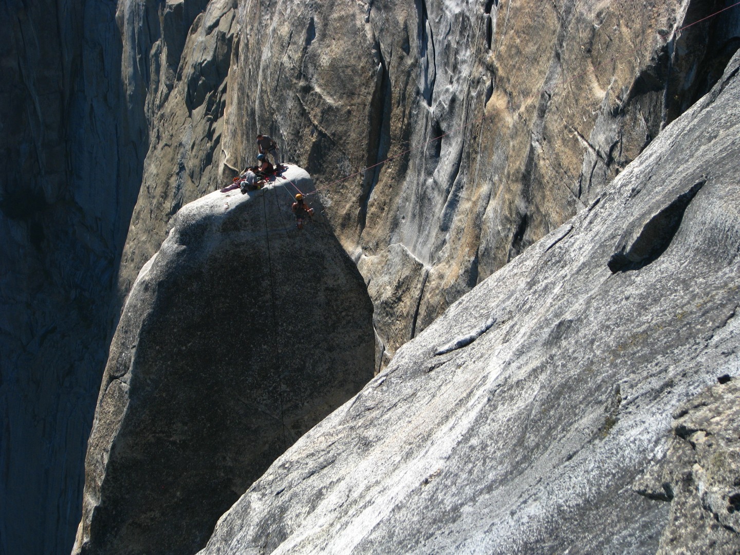
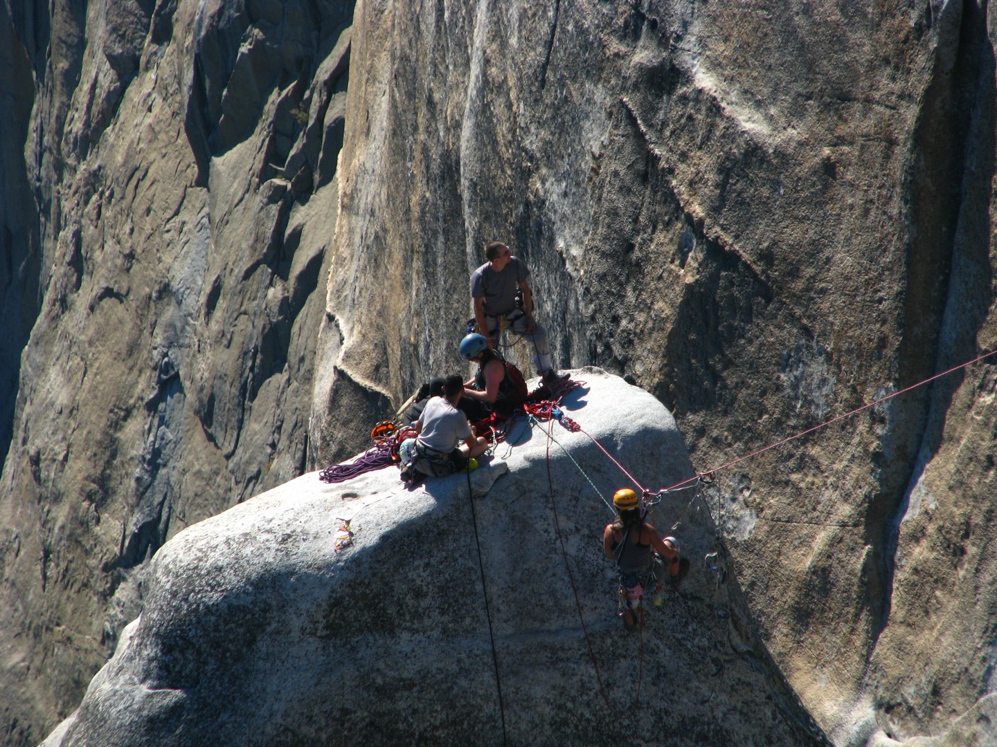
standing, and we were looking right at Lost Arrow, and there were 3
climbers on top of the Arrow and another climber jumaring the span over
to the Arrow. This was fantastic! I told them this was
‘Lost Arrow’ – they were Russian, and one of them repeated ‘error’ a
few times – finally the other one mimed a bow and arrow to explain the
name. After another minute or two I got up the nerve to ask to
borrow their camera and they happily agreed. I quickly took about
15-20 shots of the Arrow and the Valley below. This was a DSLR
and it took great pictures averaging 5 meg in size.
The
View from Yosemite Point - this picture is a composite of pics taken
with the Russian's borrowed DSLR
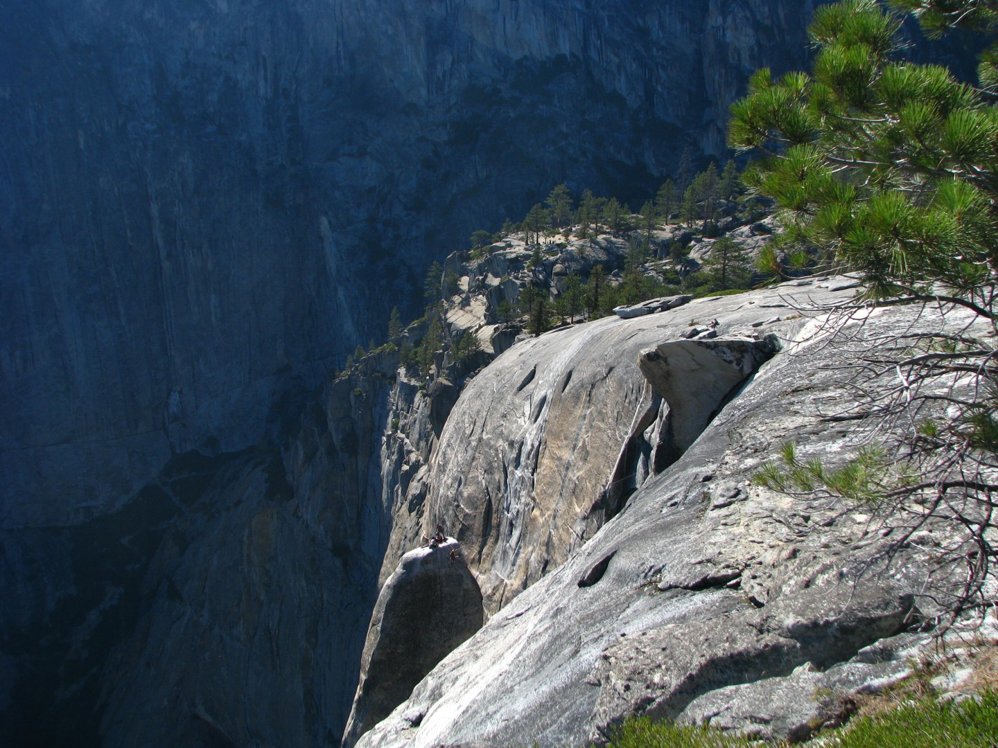
Lost
Arrow
The switchbacks of the Yosemite Falls
Trail are visible in the shade on the left
This picture was taken with
the Russian's borrowed DSLR
This
picture was taken with the Russian's borrowed DSLR
This
picture was taken with the Russian's borrowed DSLR
It was now after 4pm and I was really running late. I figured
best case it would take another 2 hours to get down to the Valley, and
then it would take at least another 30 minutes to get back to Upper
Pines. I called Kathy and left a voicemail, and Kathy quickly
called back on CJ’s phone. She said her phone rang but wouldn’t
pick up and the voicemail would work, and CJ’s phone was nearly out of
batteries. I gave her an update on my ETA.
The trail down from Yosemite Point to the creek is very hard to follow
– I found scattered pylons, but lost the trail several times. You
could see where you needed to end up so there was no real danger of
getting lost, but I wanted to be done with this hike. Eventually
I found the bridge over the creek. In early September the creek
was a collection of puddles and was no longer flowing.
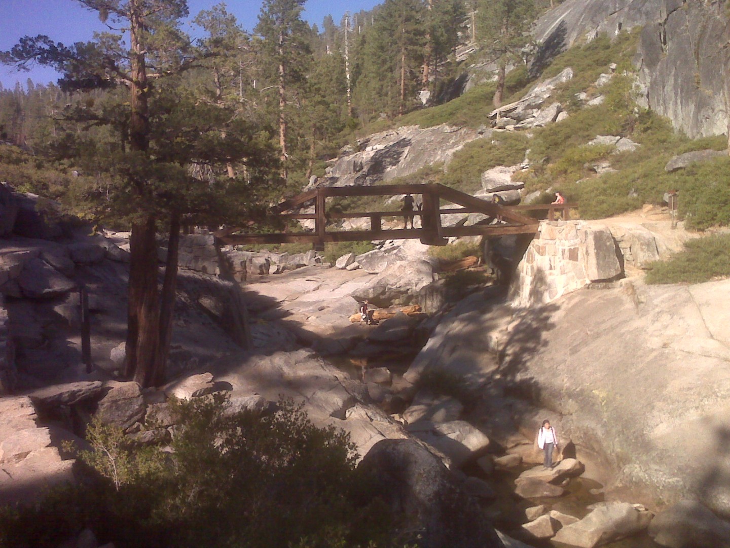
Yosemite
Creek Bridge - picture taken by my Blackberry
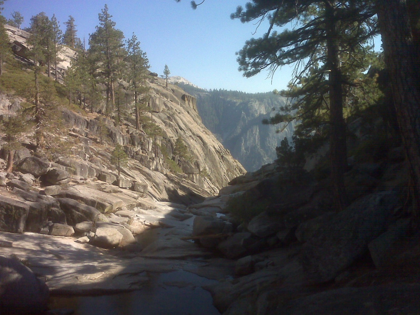
Yosemite
Creek, headed towards Yosemite Falls - picture taken by my Blackberry
After the
bridge there was a sign indicating the overlook to Yosemite Falls was a
quarter mile away. I didn’t want to spend the time or energy, but
I wasn’t going to miss it either, so I trudged off towards the
overlook. Eventually you get to a cliff and a lone sign directs
you to the left. A set of stairs leads down (remember how
I’m tired of climbing up after 15+ miles of hiking?). Then the
stairs get very steep and follow a metal railing – beyond the railing
is a short ledge, and beyond that is a 1000’+ fall. Eventually
you see a dry 30’ waterfall leading to a large pool, which drains
towards Upper Yosemite Falls, which are still out of sight
somewhere. There were perhaps a dozen teenagers climbing up,
down, and around the pool and dry falls, and traversing over to the
falls from the dicey trail I was on. I then found the stairs that
continued towards the overlook. There is a very abrupt transition
a) You can suddenly see the entire valley
below you, as well as the overlook and the Falls itself
b) The stairs and the outer railing end
c) The path down to the overlook is
now a narrow 18” ledge along the cliff about 30’ over the Overlook
itself.
d) There is a single railing on the cliff
side of the path and no outer railing, making this perhaps the most
exposed ‘path’ I have ever seen. I had no problem with the Garden
Wall exposure in Glacier, but this was nuts. This was as far as I
was going.
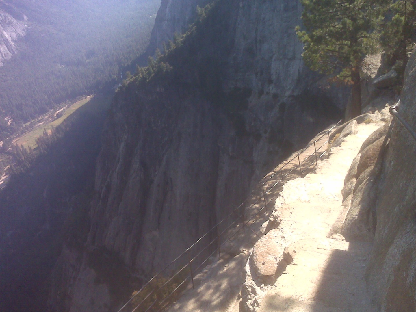
Yosemite
Falls Overlook - picture taken by my Blackberry
I climbed back up the stairs and walked back to the main trail. I
then started down the Yosemite Falls trail. It was now
approaching 5pm.
It was perhaps the steepest trail I’ve ever hiked, and was almost
entirely granite stairs, covered with gravel and dusk to make it very
slick. The only other trail I'd been on like this was Hermit
Trail in the Canyon and I absolutely despised that trail. I was
now completely exhausted and I didn’t dare take big steps cause I knew
I’d slip and fall. I saw a family – two adults and a young girl -
headed down very, very, slowly, but I didn’t see anyone else. As
you head down the canyon wall become larger and larger, and soon it is
looming several hundred feet over you. Reminded me of the Grand
Canyon. I kept hiking down, down, and down. I slipped once
and nearly did a faceplant, saved by my hands. Once I got out of
the canyon next to Upper Yosemite Falls I never even bothered to look
back to see the falls – I just kept hiking. It was now
approaching 6pm. I left Kathy another voicemail, then tried both
CJ and Robby’s phones. Kathy called me back on Robby’s
phone. I asked her to bring me a complete change of clothes, some
water, some soap, and paper towels, and meet me at the food court at
Yosemite Lodge in about 45 minutes.
As I continued hiking the trail went uphill again…
unfortunately. The trail was almost entirely in the trees,
though occasionally I could sense that there was some serious exposure
just past the treeline. Finally I got past Columbia Rock, headed
down the now non-granite trail, and made it to Camp 4 at around 6:40 –
I called it 11 hours and 11 minutes of hiking. It was another
half mile to Yosemite Lodge – I waited there for perhaps 10-15 minutes
before the family showed up and we had dinner. I gorged myself on
a Philly cheese steak, something I would not normally select but I had
earned it.
In retrospect, I do not need to hike up Snow Creek again...
ever.
However I would love to do this hike by 'cheating' and starting from
Tioga Pass Road -
that would give me lots more time to appreciate the scenery on the
rim. The view from the rim of Half Dome is one of the most
beautiful views I've ever seen. Almost as good, it is not crowded
with teaming masses like most of the rest of Yosemite around the valley.
Previous
Saturday July 31, 2010
Rafting the Merced
|
Saturday
September 4, 2010
North Dome
|
Next
Sunday September 5, 2010
Glacier Point
|